


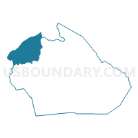
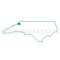
Voting District 02, Watauga County, North Carolina
About
Outline

Summary
| Unique Area Identifier | 641799 |
| Name | Voting District 02 |
| County | Watauga County |
| State | North Carolina |
| Area (square miles) | 26.80 |
| Land Area (square miles) | 26.75 |
| Water Area (square miles) | 0.05 |
| % of Land Area | 99.81 |
| % of Water Area | 0.19 |
| Latitude of the Internal Point | 36.31456500 |
| Longtitude of the Internal Point | -81.83753900 |
Maps

Graphs
Select a template below for downloading or customizing gragh for Voting District 02, Watauga County, North Carolina


Neighbors
Neighoring Voting District (by Name) Neighboring Voting District on the Map
- Voting District 03, Avery County, NC
- Voting District 08, Watauga County, NC
- Voting District 10, Watauga County, NC
- 3A Trade Voting District, Johnson County, TN
- 3B Neva Voting District, Johnson County, TN
- 4A Dry Run Voting District, Johnson County, TN
Top 10 Neighboring County Subdivision (by Population) Neighboring County Subdivision on the Map
- District 3, Johnson County, TN (3,599)
- Cove Creek township, Watauga County, NC (3,118)
- District 4, Johnson County, TN (2,594)
- Laurel Creek township, Watauga County, NC (1,947)
- Beaverdam township, Watauga County, NC (1,351)
- Beech Mountain township, Avery County, NC (672)
Top 10 Neighboring Place (by Population) Neighboring Place on the Map
Top 10 Neighboring Unified School District (by Population) Neighboring Unified School District on the Map
- Watauga County Schools, NC (51,079)
- Johnson County School District, TN (18,244)
- Avery County Schools, NC (17,797)
Top 10 Neighboring State Legislative District Lower Chamber (by Population) Neighboring State Legislative District Lower Chamber on the Map
- State House District 93, NC (78,360)
- State House District 84, NC (65,274)
- State House District 3, TN (60,934)
Top 10 Neighboring State Legislative District Upper Chamber (by Population) Neighboring State Legislative District Upper Chamber on the Map
- State Senate District 45, NC (184,898)
- State Senate District 2, TN (175,067)
- State Senate District 47, NC (168,288)
Top 10 Neighboring 111th Congressional District (by Population) Neighboring 111th Congressional District on the Map
- Congressional District 5, NC (693,414)
- Congressional District 10, NC (689,468)
- Congressional District 1, TN (684,093)
Top 10 Neighboring Census Tract (by Population) Neighboring Census Tract on the Map
- Census Tract 9563, Johnson County, TN (5,743)
- Census Tract 9564, Johnson County, TN (4,876)
- Census Tract 9202, Watauga County, NC (4,044)
- Census Tract 9301, Avery County, NC (3,100)
- Census Tract 9562, Johnson County, TN (2,446)
Top 10 Neighboring 5-Digit ZIP Code Tabulation Area (by Population) Neighboring 5-Digit ZIP Code Tabulation Area on the Map
- 37683, TN (13,021)
- 28692, NC (4,067)
- 37640, TN (3,743)
- 28698, NC (2,256)
- 28679, NC (2,064)
- 37691, TN (894)